On Monday, 11 December 2023, my twenty-one-year-old son and I set off in his van on a 10-day, 4600-kilometre dad-and-son road trip from Sydney to Margaret River. We had planned the trip for over six months to spend Xmas/New Year with our WA family and attend my brother’s/his uncle’s 50th.
And yet, I only had a vague idea of our route.
My son bought the ex-tradesman’s 2007 Toyota HiAce van in March 2023. I drew on my woodworking skills to help him line the floor, walls and ceiling and kit it out with a bed, cupboard and sink, and my long-ago days as an electrician to fit the electrics, including an auxiliary battery, solar panel, and lighting and power sockets.
The van was my son’s conception — his home while travelling for leisure and work in outdoor education — and woe betide me if I didn’t follow his instructions.
Similarly, I’d left the route planning to him for our road trip. His generation is more adept at Google Maps and other mapping and campsite booking phone apps than sixties me, and there were places my son wanted to go bouldering and climbing. I was happy to share the driving, belay him, and document our road trip:
- Day 1: Sydney to Bendigo
- Day 2: Horsham and Arapiles
- Day 3: Horsham to Adelaide
- Day 4: Adelaide to Streaky Bay
- Day 5: The Nullarbor Plain
- Day 6: Great Australian Bight to WA
- Day 7: Balladonia to Esperance
- Day 8: Esperance to Albany
- Day 9: South Coast Highway to Manjimup
- Day 10: End of the Road Trip
- Reflections
Spoiler alert: As our trip and my travel journal reminded me, you’ve got to be flexible with your plans!
Day 1: Sydney to Bendigo
The first day was a long drive, with my son announcing afterwards that according to the van’s odometer and sat nav, we’d covered almost a quarter of the trip — this proved to be an exaggeration, but only just! Our destination was Mount Arapiles in Victoria, a spectacular climbing site my son had visited earlier in the year and was keen to show me.
However, we departed Sydney later than planned, detoured via Canberra to buy camping and climbing gear, and dawdled at Gundagai for a photo in front of the Dog on the Tuckerbox and at Holbrook for one beside the beached HMAS Otway submarine.

Dog on the Tuckerbox at Gundagai (click for larger image)
When we finally crossed the border from NSW into Victoria at Albury-Wodonga and turned west instead of southwest, the sun was setting, and we were tired. So, 13 hours after we’d left Sydney, we pulled into a rest area near Bendigo, 3 hours from Arapiles, and camped overnight, my son in his van and me in a tent.
I wrote in my travel journal: “It was a good first day. Sounding out the journey and each other.”
Day 2: Horsham and Arapiles
The next day, dodgy sat nav directions and patchy mobile reception for Google Maps led to several wrong turns on the back roads to Horsham. I wanted to look at the town’s old buildings, but my son’s mission was to push on to Arapiles and start climbing.
The Mount Arapiles range rises like Uluru above the flat plains of western Victoria, and depending on the angle of the sun, its exposed rockface has a similar red-orange hue. My son chose Mitre Rock, a smaller outcrop a short distance from the Arapiles range, for his “trad climb” — climbing with “nuts” and “cams” instead of using pre-drilled bolts. Mitre Rock isn’t as high as other Arapiles climbs, but I declined his offer to join him, content to belay from the bottom.

Climbing Mitre Rock at Arapiles (click for larger image)
We set up camp in the afternoon in a campground at the base of the Arapiles range. After the long drive and climb, my son rested, and I went for a bushwalk along the rock face. It was hot, and I wanted to stay in the shade, so I followed a track leading up a sheltered gully. I stumbled on rough-hewn steps and started climbing … and they went on and on, steeper and steeper.
The steps became increasingly difficult to climb. My legs felt heavy, and my lungs were heaving. When I checked my son’s pocket guidebook (which I’d thankfully packed!), I realised I was on a track to the Arapiles Summit car park. So, I called my son, and we arranged for him to drive up and collect me, and I pushed on.
It’s only 50 metres from the car park to the Summit lookout, and I trudged it one step at a time. But the views of the flat plains and adjacent Mitre Rock were worth it, and as I noted in my travel journal, “I found the energy to scramble up the last boulder to the Summit marker, so I can brag that I’ve climbed Mount Arapiles.”
Day 3: Horsham to Adelaide
I was up early the next day and enjoyed watching the sunrise light up the Arapiles rock face. My son hadn’t slept well in the van with the overnight heat, so we went shopping and sightseeing in Horsham. He bought mosquito netting to let him leave the van doors open at night, and I got my wish to see its old buildings and tickle the keys of a streetside Community Piano.

Community Piano in Horsham (click for larger image)
We set up camp in the afternoon in a campground at the base of the Arapiles range. After the long drive and climb, my son rested, and I went for a bushwalk along the rock face. It was hot, and I wanted to stay in the shade, so I followed a track leading up a sheltered gully. I stumbled on rough-hewn steps and started climbing … and they went on and on, steeper and steeper.
The steps became increasingly difficult to climb. My legs felt heavy, and my lungs were heaving. When I checked my son’s pocket guidebook (which I’d thankfully packed!), I realised I was on a track to the Arapiles Summit car park. So, I called my son, and we arranged for him to drive up and collect me, and I pushed on.
It’s only 50 metres from the car park to the Summit lookout, and I trudged it one step at a time. But the views of the flat plains and adjacent Mitre Rock were worth it, and as I noted in my travel journal, “I found the energy to scramble up the last boulder to the Summit marker, so I can brag that I’ve climbed Mount Arapiles.”
Day 4: Adelaide to Streaky Bay
It rained overnight, and I woke early to find our washing sodden on the clothesline. Thankfully, the caravan park had coin-operated dryers, so I searched Google Maps for the shortest walking route to a cafe and set off for a coffee. (“Could I have my change in one-dollar coins, please?”)
After breakfast and drying our clothes and the tent, my son and I left Adelaide and headed north to Port Augusta. We stopped briefly in Snowtown, setting aside its grisly recent history to potter in an eclectic secondhand goods warehouse where he bought his mum a vintage David Attenborough book for Xmas, Zoo Quest for a Dragon (Readers Book Club, 1957).
But the highlight of the Port Augusta section was spotting a road sign for Perth. I was driving, and my son took a photo and posted it on our family WhatsApp group with the question: “Should we take the left fork to Perth or the right to Darwin?”

Port Augusta road sign to Perth (click for larger image)
Instead, while my son dozed, I drove us to Smoky Bay for a brief, soothing stop to paddle my feet on the beach before carrying on to Ceduna, where a crossroads sign listing the distances to Sydney and Perth confirmed we’d travelled over halfway.
We found a well-stocked camping store in Ceduna, and I bought myself a $30 tent, rejecting my son’s assurance that I could still use his tent. “Thanks,” I said, “but I don’t want to risk any more inadvertent accidents or mornings like today on this trip.”
Our next stop was for fuel in Penong. A large sign in front of a general store warned, “Last Shop for 1000 km” — a dubious assertion, as it’s only 420 kilometres from Penong to Eucla, with several roadhouses in between. But I still bought two ice creams (just in case!), which we ate while visiting Penong’s other claim to fame, “Australia’s Biggest Windmill”, in a quaint outdoor museum.
Day 5: The Nullarbor Plain
Neither of us had a good night’s sleep, with noisy fellow campers chatting around a fire on the beach until late and our neighbour loading up his 4WD and boat at 3:00 AM and returning three hours later to gut his catch and feed the screeching gulls and pelicans.
And then my sleep-deprived son and I had a falling out over a small hole I found in the floor of the expensive tent he’d loaned me.
We drove in stony silence into town, where we had breakfast on the deck of a cafe offering spirit-lifting views of the jetty and bay. I felt like tossing my son the van keys and telling him I was staying in Streaky Bay!

Cafe breakfast view at Streaky Bay (click for larger image)
We had planned to climb and camp at Tcharkuldu Rock. But my son said his arms and fingers hurt from indoor bouldering with friends in Adelaide last night and climbing at Arapiles, so we pushed on to Streaky Bay for a swim. (Unfortunately, the beach was as inviting as a mangrove swamp at low tide when we arrived.)
It was another long day on the road, 700 kilometres and over 8 hours with stops. For the last half hour, we headed west into the setting sun. I was driving again and could barely see through the windscreen until I pulled over, and my son washed off the dead bugs and grime streaks with his towel. But on that tiring stretch, Google Maps confirmed we’d passed the halfway point of our road trip.

Australia’s Biggest Windmill at Penong (click for larger image)
I drove again, listening to Harry Potter, narrated by Stephen Fry, on my headphones (a series I recommend for long journeys), letting my son rest. The Eyre Highway is well maintained and makes for good driving, but I had to contend with gusty crosswinds, passing road trains (including 4-stage trailers!), and an oncoming 4WD overtaking a truck.
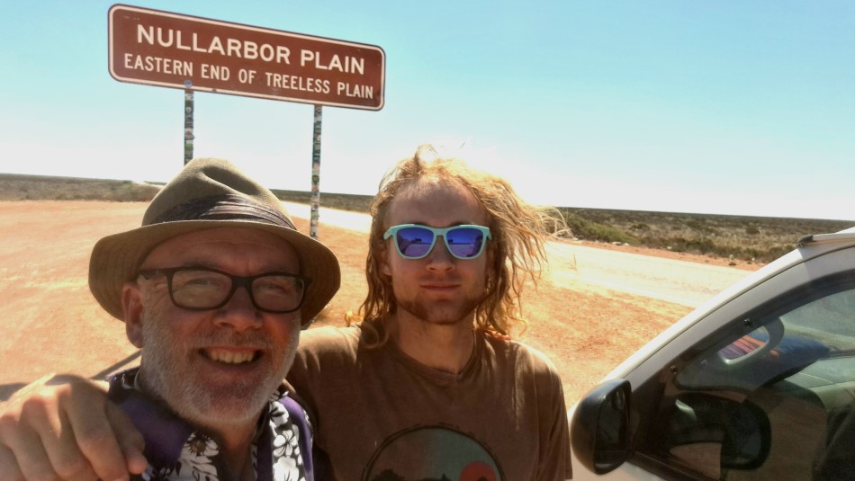
Between Yalata and the evocatively named Nullarbor Roadhouse, I pulled off the highway to take one of my favourite dad-and-son photos of the road trip in front of the signpost marking the eastern end of the treeless Nullarbor Plain — the cover photo for this blog post. It was a pinch-me moment I know I’ll treasure forever.
My son took over driving to the site he’d chosen for our overnight camp, Gilgerabbie Hut (Google Maps), on a deserted shepherd’s outstation, 10 kilometres west of the Nullarbor roadhouse and 10 kilometres south of the Eyre Highway, down a corrugated gravel road.
Despite a strong wind from the Great Australian Bight, which forced me to set up my new tent in the lee of the stone hut and the van, it was quiet at Gigerabbie — very quiet! The big sky views across the flat, treeless plains were amazing and inspired me to stream the 1986 song by The Triffids, Wide Open Road, on repeat while I cooked dinner.
After dinner, I took another of my favourite dad-and-son photos of our silhouettes sitting in camp chairs as the sun set behind us, enjoying a drink together (friends again!).

Sunset silhouettes at Gilgerabbie Hut (click for larger image)
Day 6: Great Australian Bight to WA
The star-strewn sky was worth the trip to the Gilgerabbie Hut’s drop toilet in the middle of the night. But it was hard to get back to sleep as the wind had built up, and the tent was flapping on my head. Thankfully, the wind died down in the morning, and when I got up at sunrise, it struck me how quiet it was, with only the occasional chirping bird.
We packed up camp and got away earlier than usual, with my son driving back down the gravel road. Although we had lost phone reception for Google Maps, the van’s sat nav (reliably!) informed him the Eyre Highway was now running close to the edge of the Great Australian Bight. He turned left down another gravel road, and we soon saw the Southern Ocean on the horizon beyond the approaching cliff edge.
My son has long been into activities that make me nervous, such as cliff jumping, parkour, slacklining and highlining, bouldering and rock climbing, and canyoning. From the moment we floated the idea of the road trip across Australia, he’d spoken of his intention to “abseil off the edge of Australia”.
“Don’t worry, Dad,” he said, laying a reassuring arm around my shoulder. “I’ll be safe.” I tried to walk off my anxiety along the cliffs, taking selfies and photos of my son setting up with a line secured to a rock on the cliff face and a backup tied to his van. But I couldn’t watch when he lowered himself down the rocky slope, and I didn’t relax again until his helmeted head reappeared over the edge.

Abseiling at the Great Australian Bight (click for larger image)
We drove further along the highway to a more touristy turnoff (a shorter gravel road to the fenced cliff edge), offering a classic postcard view of the Bight, with the sheer cliff faces cutting away to the east. It was also an opportunity to pass on our leftover oranges and unopened honey to tourists travelling east before the WA quarantine station.
Entering WA felt like crossing a “real” border, something I’d last experienced in my backpacking days. But the uniformed officer’s quarantine check of the van’s fridge was good-natured, and he duly waved us into our fourth state (and one territory) since leaving Sydney.
The terrain became more scrubby towards Eucla, and beyond that, heading on to Balladonia, there were scraggly trees. It felt like we’d passed through the treeless plains of the Nullarbor in the blink of an eye.
My son and I took turns driving and reached the Balladonia roadhouse with plenty of time to set up the van and tent in the adjacent hard-packed, red-earth campground and have a much-appreciated shower (our first in two days) before Chinese dinner at the roadhouse restaurant (I loved the stir-fried veggies!).
Later, my son showed off his skills juggling on a slackline. He tried to teach me juggling tricks, but I wrote in my travel journal: “I was too rusty on the basics to master any tricks.”

Juggling on a slackline at Balladonia (click for larger image)
Day 7: Balladonia to Esperance
There was a massive thunderstorm overnight, with close flashes of lightning, loud claps of thunder, and a heavy downpour. Fortunately, my $30 tent kept me dry, but the rain turned the red earth outside the tent into mud.
My son and I squelched through the mud to pack up my tent during a dry spell before breakfast at the roadhouse. Then, we visited the adjoining museum to learn how Balladonia made worldwide news in 1979 when NASA’s Skylab space station reentered the atmosphere and spread debris across the local area.
It was a 2-hour drive to our next fuel stop, Norseman, which is like a T-junction, with the highway heading north to Coolgardie and south towards Esperance. I stopped there briefly in 1983 on a bus from Perth to Melbourne when I was twenty-one. The bus had travelled from the north, the shortest route from Perth. Forty years on, I was heading south with my twenty-one-year-old son to loop around the southern coast of WA.

T-Junction at Norseman (click for larger image)
I don’t know what I expected of Esperance, having only seen it on TV or read about it in the news. Perhaps I pictured a “surfie town”? But the surf near our “beachside” caravan park (a block back from the beach) was flat.
After last night’s noisy thunderstorm, my son needed to catch up on his sleep, so I left him at the campsite and went for a long walk along the esplanade, back towards the town centre. It was good to “throttle back” from several all-day drives and enjoy the harbour views. I shopped for the night’s dinner and had a leisurely beer at a pub looking out at the harbour.
The walk along the esplanade was tiring, and I knew it would take ages to return to the caravan park. So, I hired an e-scooter and rode back, which was fun. I had been gone for a while, but as I recorded in my travel journal, I laughed when my son called me: “Where are you, Dad?” “Part your curtains, mate.”
Day 8: Esperance to Albany
The one thing I knew about Esperance (from watching a recent Bill Bailey’s Wild West Australia on ABC TV) was that it has a full-sized replica of Stonehenge. I visited the real Stonehenge with my young son on our second day in England in 2007, and I was keen to see the Esperance version with him.
However, while I was excited to walk about the replica stones as they would have stood 4000 years ago in the days of druids and mammoths, my son was as underwhelmed as he had been as a jet-lagged five-year-old. And that’s a shame because, in my opinion, the Esperance Stonehenge is a sympathetic homage to the original on Salisbury Plain.

At Stonehenge in England, 2007 (click for larger image)

At Stonehenge in Esperance, 2023 (click for larger image)
It was another long drive from Esperance to Albany, with the highway running through hilly pastures dotted with trees — it was greener, but I missed the dry Nullarbor scenery. We encountered our first traffic light since Adelaide at a road works zone, and it was red. When we stopped, the van’s Check Engine Warning light came on, and my son had a minor panic attack.
I suggested we “nurse” the van to the next petrol station, check the oil and water and see if the light went off, as it had in Sydney the week before we set off. The light stayed on, but Googling it reassured us the van wasn’t about to break down and we could investigate the problem in Margaret River or Perth.
My son dropped me at the hotel in Albany he’d booked for me for the night and headed off to catch up with friends camping further along the coast. (He texted shortly afterwards that the Check Engine Warning light went off in a nearby supermarket car park!)
The hotel described my overnight accommodation as a “Shoe Box Room”. I requested another room because my “shoe box” was above the beer garden. “Do you mind sleeping in a single bed?” the receptionist asked. Erm, I’ve been sleeping on a camp stretcher in a tent for the past week.

My “Shoe Box Room” in Albany (click for larger image)
Day 9: South Coast Highway to Manjimup
After cranking up the room’s pedestal fan to level 3, shoving in the hotel’s complimentary earplugs, and drinking several cans of stout before bed, I slept reasonably well. But I woke early, with my body clock still set to Nullarbor time, so I went for a long walk.
I paused for a selfie at the old Albany Train Station, where I had disembarked with two mates from Perth for the best holiday of my teenage years in the 1970s. Then, I trekked uphill through the Heritage Park and Anzac Memorial to Mount Clarence, a place of reflection offering stunning views of Albany and the surrounding bays.
Fortunately, I found a shortcut bush track back to town and arrived at the hotel in time to meet my son. He seemed distant and reserved. The night with his friends may have reminded him of the freedom of not travelling with his dad. (And maybe he’d had a big, late night with them?)
We had a hearty brunch in Albany and then drove to Monkey Rock, near Denmark (where he’d camped last night), to go rock climbing. It was a short, steep track from the car park to the rock. I enjoyed walking in the bush. But I noticed more flies in WA than elsewhere on our trip, and I soon regretted leaving the Aeroguard in the van!

Bush track to Monkey Rock (click for larger image)
A mum and dad with two young kids arrived as my son was setting up for a “sport climbing” run (clipping onto bolts into the rock face, rather than “trad climbing” as he’d done at Arapiles). They were also planning to climb themselves and with the kids. I explained I was only belaying my son. “Why?” they asked. “Because I haven’t got a head for heights,” I told the mum and dad and then looked at their kids. “But don’t let that stop you guys from having fun!”
(The family was from the Hunter region, north of Sydney, and travelling around Australia. When they got to the road sign in Port Augusta, they’d turned right, headed north to Darwin and would return home across the Nullarbor – my son gave them tips for abseiling off the Bight!)
My son climbed a few routes, including a vertical “crack”. I made a few stuff-ups belaying him but didn’t get yelled at (too often!). He scrambled up a boulder to retrieve his rope (stuck by friction on the rock face) and made it look easy. “Could I try that?” I asked. “Yeah,” he replied, “but I’ll lead belay you for safety.”
I made the climb look difficult, grabbing plants as “aids” to haul myself up the rock face. But then we scrambled up another boulder to the top of Monkey Rock, and it was well worth the effort for the windswept coastal views — and another prized dad-and-son selfie from the summit!

Summit of Monkey Rock (click for larger image)
The tide was surging, and the waves were too rough for a swim on the coast, but we had a refreshing (freezing!) dip in a sheltered shallow pool to wash off the sweat from our climb. Back on the road, we had decided to skip Margaret River for now and head to Perth instead but hadn’t settled on where to spend the last night of our revised road trip.
And then I remembered a caravan park in Manjimup where I’d stayed with my father and brother in my pre-teenage years. It was close to the southern forests and would be a good base for tomorrow’s 3 to 4-hour drive to Perth. Serendipitously, as my son and I pulled into town, I spotted a Tall Timbers Brewery pub and restaurant across the road from the caravan park, perfect for our last dinner on the road.

Dinner at Tall Timbers Brewery in Manjimup (click for larger image)
Day 10: End of the Road Trip
I woke early (again!), packed up my tent and left it beside my sleeping son’s van to walk into town for a coffee and to buy English muffins to toast for our last campsite breakfast. I wrote in my journal: “It’s hard to comprehend the kilometres we’ve travelled.”
My son took the first turn driving. I enjoyed the passing scenery, the mix of forests, farmland and small towns, like Kirip, where every property featured a different Santa tableau out the front, for example, Santa playing a full-sized drum kit. My son commented it looked like the town had bought a container of Santa mannequins.
When we drove through forested areas, I craned forward to get a better view through the windscreen. “Are you okay?” my son asked. “Yes, mate,” I assured him, “I’m just enjoying the trees.”

Southern Forests of WA (click for larger image)
We stopped for lunch in Donnybrook, which, with its apple-themed street, park and playground decorations, felt like the last quaint town of our trip. I swapped driving duties, and before we knew it, we were on the Forest Highway to Perth (with no sign of forests!).
The original plan (conceived in Sydney) was to end our road trip at Margaret River. My son would stay there with his van, and I’d catch a bus to Perth (3 hours north) and help my brother drive down with my niece for family Xmas festivities. However, my son suggested we head to Perth together and stay with my brother for a couple of nights before making our way to Margaret River independently.
The change of plan meant that our dad-and-son road trip technically ended in Perth, or to be precise, in Fremantle, where we toasted our achievement at the Little Creatures Brewery with my brother, whose 50th birthday had inspired us to make the trip.

Cheers at the Little Creatures Brewery, Fremantle (click for larger image)
My son and I had travelled for 10 days and over 4800 kilometres since Sydney. Despite occasional disagreements, a few cuts and blisters from climbing, and the Check Engine Light (which had come on again!), we had made the journey unscathed and in good spirits … most of the time.
Reflections
I’ve mentioned that the road trip with my son was my second crossing of the Nullarbor. My first was on a bus from Perth to Melbourne in 1983 when I was twenty-one, the same age he was on our trip.
As I shared in a June 2023 blog post to mark my son’s twenty-first, I spent most of the 1983 journey in a stupor of sleeping pills. I remember getting off the bus at Southern Cross in the middle of the day, where it was very hot, at Norseman late at night, where it was very cold, and in Adelaide at dawn the next day, where I joined a group of backpackers a very early-opening pub.
Apart from this, I have no memories of my first crossing of the Nullarbor.

That 1983 bus trip was 40 years ago. But even with our occasional “falling outs” and silences, I hope my son remembers his first crossing of the Nullarbor clearly and fondly 40 years from now.
It’s unlikely I’ll be around then, but while I am, I won’t forget our dad-and-son road trip, especially standing with my son in front of the Nullarbor Plain road sign.
© 2024 Robert Fairhead
N.B. You might like to read Love Being a Dad, a blog post I wrote for my son’s eighteenth birthday in June 2020.
Note: This post originally appeared on Tall And True writers’ website.


About RobertFairhead.com
Welcome to the blog posts and selected writing of Robert Fairhead. A writer and editor at the Tall And True writers' website, Robert also writes and narrates episodes for the Tall And True Short Reads podcast. In addition, his book reviews and other writing have appeared in print and online media, and he's published several collections of short stories. Please see Robert's profile for further details.


0 Comments